NASA Earth Science
NASA, University Hospitals Join Forces in Response to COVID-19
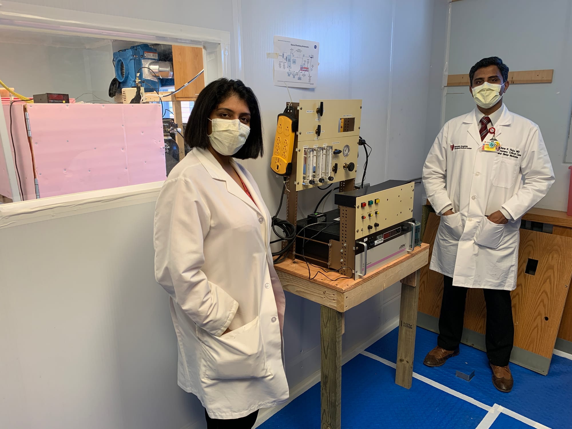 Doctors Amrita John and Shine Raja at UH Cleveland Medical Center with the device that decontaminates masks using atomic oxygen.
Credits: University Hospitals
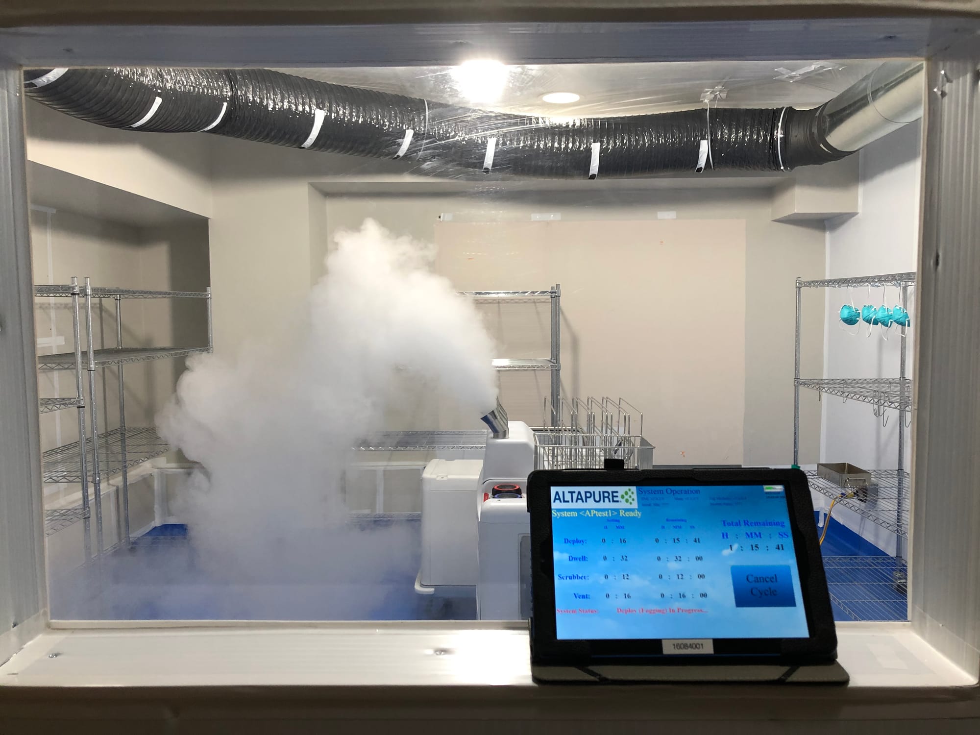
The decontamination room at University Hospitals where the N95 masks are disinfected using the per acetic acid method.
Credits: University Hospitals
NASA’s Glenn Research Center and University Hospitals (UH) in Cleveland have collaborated to develop new methods and technologies for decontaminating personal protective equipment (PPE) for aerospace applications and for safeguarding the health of workers caring for patients with coronavirus (COVID-19).
A team of researchers recently developed and tested two new approaches that could enable health care professionals to sanitize masks on-site and safely reuse them. These approaches also may be useful to the aerospace community when traditional sterilization techniques might not be available.
“NASA strives to ensure the technology we develop for space exploration and aeronautics is broadly available to benefit the public and the nation,” said Glenn Center Director Marla Pérez-Davis, Ph.D. “If our technology can lend a hand in overcoming this crisis, we will do whatever we can to put it in the hands of those who need it.”
Results of tests on both methods – atomic oxygen and per acetic acid – are promising. The atomic oxygen decontamination method currently is being evaluated and early results are favorable. The per acetic acid method has been proven to work for five cycles of decontamination, and the Food and Drug Administration is reviewing this method for an emergency use authorization.
“While we currently have sufficient PPE on hand to care for the patients we have in our facilities today, we need to proactively and prudently plan for potential future needs,” said Dr. Daniel I. Simon, chief clinical and scientific officer at University Hospitals and president of UH Cleveland Medical Center. “This includes factoring in the potential for supply chain shortages due to COVID-19 surges in other states while also taking into account our need to restart non-emergent and elective services, which requires being mindful about current usage and putting in place go-forward conservation strategies. The opportunity to pool resources and quickly bring about PPE sterilization solutions for the benefit of our caregivers is truly remarkable.”
Atomic Oxygen Method
Glenn research engineer Sharon Miller and physicist Bruce Banks of SAIC developed a process and hardware to decontaminate masks using atomic oxygen. Pervasive in low-Earth orbit, these single oxygen atoms can remove organic materials that can’t easily be cleaned by other methods.
“On Earth, we create atomic oxygen by putting ozone (O3) in a chamber and heating it,” Miller said. “As the ozone decomposes into atomic oxygen, it can kill organisms like viruses.”
Further testing is needed to verify the method can be used to perform multiple decontamination cycles without damaging the PPE. Recent filtration tests performed at an independent testing laboratory showed N95 masks filter well and pass acceptance testing after 20 minutes of atomic oxygen treatment. In early May, NASA provided a prototype for UH to test on N95 masks. Early results confirm the method deactivates the virus, and continued testing will determine the minimum ozone concentration and exposure time needed for disinfection.
“Ozone diffuses easily through and around objects, which makes it promising for sterilizing inside an N95 mask filter or loosely stacked masks, and it could potentially sterilize without leaving a residue,” said Banks, who supports Glenn’s Environmental Effects and Coatings branch. “The process could be scaled up to treat multiple batches of PPE or made portable for small hospitals in rural areas. No liquid chemicals would be needed, just oxygen and nitrogen gas.”
Per acetic Acid Method
Doctors Amrita John and Shine Raja, infectious disease and critical care physicians in the Department of Medicine at UH Cleveland Medical Center, are examining per acetic acid – a chemical disinfectant commonly used in the health care, food, and water treatment industries – as an option for decontaminating PPE.
“We have some exciting results,” said Raja. “We found that the per acetic acid disinfection method is very effective in killing 99.9999% of viruses and even highly resistant bacterial spores from contaminated N95 masks without any detectable loss of filtration, structural integrity and strap elasticity for up to five decontamination cycles. We believe that the per acetic acid disinfection method is the fastest method of mass-decontamination of N95 respirators currently available.”
The U.S. Department of Veterans Affairs, Case Western Reserve University, and Glenn are participants in this multi-institutional study.
“It has been amazing to collaborate with such a multidisciplinary group of researchers and practitioners to discover innovative ways to conserve PPE,” said John. “As physicians and researchers, we aim to develop solutions that can work for the multitude of PPE categories as well as the variety of operational needs of a given hospital or health system. In some instances, there may be needs beyond the FDA-approved methods currently in place, and we want to ensure we are well-positioned to offer options for our patients and health care workers should circumstances arise.”
Dr. Curtis Donkey, an infectious disease physician at the Louis Stokes Cleveland VA Medical Center, supervised the microbiology testing for the per acetic acid study.
“The disinfection system could provide a means for in-hospital decontamination of large amounts of PPE during the coronavirus pandemic,” said Donkey. “Further testing is needed to determine if more than five decontamination cycles can be performed with no adverse effects on PPE performance and we aim to assess that over the next several weeks.”
This collaboration was facilitated by UH Ventures, the innovation and commercialization arm of University Hospitals.
“We have been successfully leveraging relationships with health care, technology, and supply chain providers across the state to bring to fruition several innovations that have addressed caregiver needs during this pandemic,” said Kippur Lee, managing director of the UH Ventures Innovation Center and co-lead of the alternative PPE strategy team. “We have been honored to join forces with the NASA team, as well as researchers at the VA and Case, to promote innovation discovery in this new frontier.”
New NASA Research Projects Probe COVID-19 Impacts
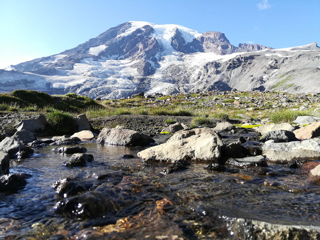
Mount Rainier in Washington is home to one of hundreds of snow-monitoring stations positioned throughout the western U.S.
Credits: Valid Braun/Unlash
The new projects look at food- and water-supply stability and how changes in human activity are affecting the environment.
The COVID-19 pandemic has touched most aspects of human life. In recent months, NASA has initiated research projects focused on how the human response to the pandemic has affected our environment, like how air quality has improved in the wake of reduced vehicular traffic in many places. But the tentacles of the pandemic extend well beyond that.
How have production disruptions affected agriculture and food supply? What about our ability to forecast water availability in coming months? How do changes in activity levels affect environmental conditions?
NASA's Earth Science Division recently selected three new projects that aim to answer these and other pandemic-related questions for Rapid Response and Novel Research (RRNES) awards. RRNES is funding quick-turnaround projects that make innovative use of the agency's resources and data to better understand regional-to-global environmental, economic, and societal impacts of the COVID-19 pandemic.
The new projects join a growing list of RRNES research now underway.
Food Supply Monitoring
Shutdowns in response to COVID-19 left many farmers facing two distinct problems: labor shortages brought on by travel restrictions, and falling demand resulting from the closures of restaurants and schools. Realizing that their labor costs would exceed the value of their crops, some farmers decided to forgo harvesting them.
The impacts don't stop there. The economic downturn and related unemployment put food security at risk for many people, especially in developing countries. Import and export restrictions, COVID-19 outbreaks in and around port cities, and other supply-chain disruptions have all added to uncertainty in agricultural markets. In order to monitor the development of crop conditions globally, these factors and others need to be taken into consideration.
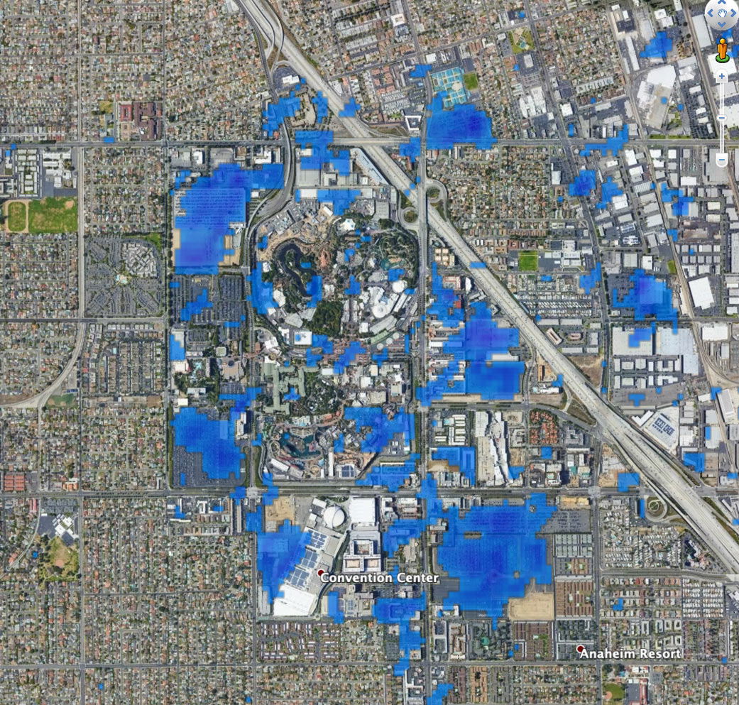
This preliminary map shows the slowdown of activity at Disneyland in California. Areas in blue indicate a reduction in vehicle concentration or movement as a result of COVID-19 pandemic response efforts.
Credits: NASA/JPL-Caltech/EOS at Nanyang Technological University
University of Maryland scientist and NASA Harvest data lead Michael Humber and his colleagues are working on a project that brings all of the relevant Earth Science data together in one easy-to-access place. In line with the mission of NASA's food-security-focused program, NASA Harvest is striving to expand open access to agricultural data that can help inform food policy decisions.
"Our goal is to provide an interactive, web mapping tool that will show you, in just a few clicks, the international and national market situation and primary food-crop assessments supported with remote-sensing data," Humber said. "You would be able to combine this data with the Johns Hopkins COVID-19 tracker data and the latest pandemic-related updates."
The information available through the tool will provide policymakers, humanitarian organizations, and others with vital information needed to respond to supply disruptions and other challenges proactively and to make the best decisions for their respective communities.
Preserving Water Supply Forecasts with Remote Sensing
In the semiarid western U.S., farmers and water resource managers rely on water supply forecasts both to ensure there is enough water to meet demand and to make the most efficient use of the water available.
The primary variable in these forecasts is what's called snow water equivalent, which is the amount of water contained in the snow that accumulates and compacts over the winter. In spring and summer, snowmelt becomes a significant freshwater source. Each month, surveyors take manual measurements of snow water equivalent at hundreds of monitoring stations across the region.
But what happens when a global pandemic limits the surveyors' ability to travel and take these measurements?
"As the pandemic evolved, we quickly discovered that the ground-based data that water resource managers have historically relied on for their decision making is potentially not going to be as readily available as it was in the past, because it requires people in trucks or in helicopters going out into the field to make these measurements," said University of Colorado scientist Noah Moloch. "Our project will leverage remotely-sensed snow data to fill these data gaps."
In doing so, Moloch and his colleagues hope to minimize disruptions to the water supply forecasts on which so many water and agricultural professionals rely.
Activity Mapping: Slowing Down and Speeding Up
Most governments responded to the COVID-19 pandemic by implementing some form of shutdown; however, shutdown orders and their enforcement have varied extensively at local, national, and global levels. To determine what effects these reductions in activity have had on virus control and on the environment, we need to look at the global picture. Luckily, satellites make that possible.
Scientist Sang-Ho Yun and his team at NASA's Jet Propulsion Laboratory, along with researchers from the Earth Observatory of Singapore, are using satellite-derived synthetic aperture radar (SAR) data to map changes in activity levels in cities around the world.
SAR data can show changes to Earth's surface over time. In this case, the scientists are looking at things like how the concentration and arrangement of cars in parking lots and on highways has changed from pre-pandemic patterns as well as changes to construction sites.
"Using the SAR data, we'll be able to provide citywide maps that quantify the changes in activity, both the slowing down due to lockdowns and the gradual increase as governments decide to reopen," said Yun. "These maps will help us to better understand how activity reductions correspond to different cities' levels of success in controlling virus outbreaks, and how those reductions correspond to observed improvements in environmental conditions like air quality."
Research from this project will also be incorporated into NASA's COVID-19 dashboard.
NASA accepts proposals for new ONES research on a rolling basis.